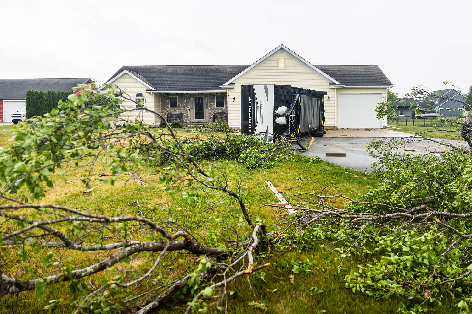
A brutal combination of early summer heat and violent atmospheric clashes has knocked out electricity for nearly 390,000 customers across the Midwest and grounded thousands of flights from Chicago to New York. This is not just a localized bad day of weather. It is a stark exposure of a fragile electrical infrastructure unable to cope with the physics of a changing climate. As a massive cold front from Canada collides with an exceptionally humid, unstable air mass surging from the South, a multi-day severe weather outbreak is shifting eastward into the Ohio Valley and Northeast, threatening over 125 million Americans.
The structural failure of our power distribution networks during these events highlights a deeper crisis. Wire and pole infrastructure remains fundamentally unprepared for the hyper-localized, high-velocity wind events that define modern summers.
The Collision of Volatile Air Masses
The atmospheric dynamics fueling the current crisis trace back to a steep dip in the jet stream. This structural anomaly has allowed an unseasonably cool, dense air mass from western Canada to plunge deep into the American interior. At the same time, the Gulf of Mexico has been pumping a relentless corridor of high-dewpoint moisture upward through the Mississippi Valley. When these two air masses met on June 10, the result was a explosive release of convective energy.
The National Weather Service logged more than a dozen tornado reports spanning Iowa, Missouri, Kansas, and Illinois.
The primary culprit behind the widespread power grid failure was not the tornadoes themselves, but a phenomenon known as a bowing line of thunderstorms. As cold air aloft drops rapidly out of a collapsing storm cloud, it creates a powerful downdraft. When this downdraft hits the ground, it rushes forward, shaping the storm front into a bow on radar imagery. This mechanics generates straight-line winds exceeding 75 miles per hour, mimicking the destructive footprint of a Category 1 hurricane without the rotational signature.
The Mechanics of Air Mass Recovery
- The Cap Breaks: Intense morning solar heating warms the ground, breaking the atmospheric "cap" holding back the moist lower layers.
- Rapid Ascent: Air parcels rise at extreme speeds, forming massive cumulonimbus clouds within hours.
- The Downdraft Surge: Precipitation drags cold upper-level air down, forcing it outward along the surface as a destructive wind wall.
This environmental cocktail is advancing east into an area where urban density and aging utility systems multiply the risk factor.
Why the Grid Fails Under Straight-Line Winds
Most news coverage focuses on downed trees, but the real story lies in the structural calculations of regional electric utilities. Standard wood distribution poles, which carry electricity from local substations to residential neighborhoods, are designed around baseline wind load assumptions that are increasingly obsolete.
When a bowing line of thunderstorms moves through a municipality like Cook County, Illinois, it subjects above-ground infrastructure to sustained lateral force. A single pole failing creates a domino effect. The immense tension on the overhead wires pulls down adjacent poles along the circuit, instantly amplifying a minor localized failure into a widespread multi-day outage.
[Substation] ---- [Pole 1] --X-- [Pole 2 (Snapped)] ---- [Pole 3 (Dragged Down)]
Utilities like Commonwealth Edison have deployed hundreds of crews to address downed lines, but the repair process is inherently slow. Every snapped cross-arm and shattered ceramic insulator requires physical manual replacement. Undergrounding these lines is often proposed as a definitive fix, but it carries an astronomical price tag. Moving lines beneath the earth costs up to $1 million per mile, a capital expenditure that regulated utilities pass directly onto consumers through increased rate bases.
The Aviation Chokepoint From O'Hare to JFK
The storm system instantly translated into an operational crisis for the domestic aviation sector. On Wednesday evening, Chicago O'Hare and Midway international airports implemented total ground stops as the storm core crossed northern Illinois. By midnight, more than 1,000 flights were delayed or canceled, leaving tens of thousands of travelers stranded.
The disruption quickly cascaded down the line. Because the commercial aviation network relies on tighter asset utilization, aircraft stuck in Chicago failed to arrive for scheduled departures at East Coast hubs. John F. Kennedy International Airport in New York was forced to issue its own ground stop later that night as storms and cascading delays squeezed terminal capacity.
+------------------------+      +------------------------+
| Chicago O'Hare Stop    | ---> | JFK Hub Delays         |
| 1,000+ Cancellations   |      | Inbound Aircraft Lost  |
+------------------------+      +------------------------+
Airlines face an impossible task when a line of intense storms cuts through a major cross-country corridor. Pilots cannot fly through intense convective cores due to severe turbulence and the structural hazard of large hail. Rerouting hundreds of flights around a multi-state line of storms creates immense traffic congestion in the adjacent air sectors, forcing the Federal Aviation Administration to proactively restrict the flow of traffic to maintain safety margins.
The Compounding East Coast Heat Threat
The incoming weather danger for the Northeast is not limited to high winds. It is the dangerous reality of extreme heat and high humidity acting as an amplifier for the incoming frontal line.
Cities from Washington, D.C. to Boston are experiencing temperatures climbing well into the mid-90s, with heat indices pushing past 100 degrees Fahrenheit. This extreme heat strains the localized grid before the first storm cloud even appears. Air conditioning demand forces transformers to run at peak capacity for hours on end, preventing them from cooling down at night.
| Region | Max Temperature | Heat Index | Grid Status |
|---|---|---|---|
| Midwest | 82°F – 86°F | 88°F | Post-Storm Recovery Mode |
| Mid-Atlantic | 94°F – 97°F | 102°F | High Demand / Pre-Storm Warning |
| Northeast | 92°F – 95°F | 100°F | Escalating Demand / Vulnerable Air Corridors |
When the Canadian cold front finally hits this super-heated, energy-dense air mass over the East Coast, the storm development will likely be rapid and severe. The high moisture content in the air provides the latent heat needed to fuel intense updrafts. This guarantees that the severe weather threat will remain active as the system marches toward the Atlantic coast, leaving behind a trail of overloaded grids and disrupted infrastructure.
The core vulnerability remains unaddressed. Until regional distribution infrastructure is structurally hardened against extreme straight-line winds, and until regional operators decouple critical transmission pathways from vulnerable above-ground assets, a routine seasonal clash of air masses will continue to hold the economic stability of major metropolitan regions hostage.