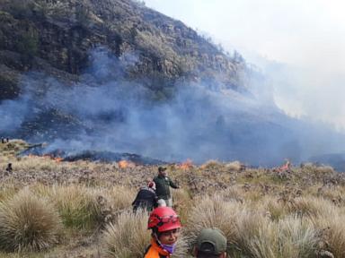
A 60-hectare surface burn in Mount Bromo National Park is not an unpredictable act of nature. It is the mathematical outcome of dense fuel accumulation, high-velocity caldera wind currents, and concentrated human traffic intersecting during a seasonal moisture deficit. Standard reporting treats these fires as tragic anomalies. A clinical analysis reveals them as cyclical operational failures driven by a misaligned incentive structure between tourism revenue and ecological risk management. This breakdown maps the exact physics of a caldera fire, quantifies the localized economic damage, and establishes a predictive framework for institutional response.
The Topographical Physics of the Tengger Caldera
The Tengger massif is defined by a massive ancient caldera, inside of which newer volcanic cones like Bromo, Batok, and Widodaren sit. This specific topography creates an optimized environment for rapid fire propagation.
The primary driver is the Venturi effect. As regional winds enter the caldera through narrow topographical gaps near Cemoro Lawang or the Penanjakan viewpoints, they compress and accelerate. When ignition occurs on the savanna slopes, these accelerated winds act as a forced-air system, driving massive amounts of oxygen directly into the combustion zone.
Fire propagation is highly dependent on slope gradients. Bromo's surrounding savanna features steep inclines frequently exceeding 30 degrees. Thermodynamics dictate that heat rises; a fire burning at the base of a slope pre-heats and dries the unburned fuel directly above it through convection and radiation. The rate of spread doubles for roughly every 10 degrees of slope. A fire starting in the flat Sea of Sand and reaching the base of Mount Batok or the caldera walls will experience exponential acceleration, quickly outpacing any manual suppression efforts.
Categorizing the Fuel Load Matrix
The 60 hectares consumed in this event consist primarily of specialized volcanic flora, dominated by Imperata cylindrica (locally known as alang-alang grass) and various scrub ferns. To accurately assess the severity of the burn, one must evaluate the fuel moisture content and the surface-area-to-volume ratio of this vegetation.
During the dry season—typically peaking between July and October—relative humidity drops precipitously. The fine grasses possess a high surface-area-to-volume ratio, allowing them to lose moisture rapidly and reach an equilibrium with the dry atmospheric air. This transforms the vegetation into highly reactive, one-hour time lag fuels. A single errant spark, a discarded cigarette, or an uncontrolled signaling device requires only seconds to establish a sustained chemical chain reaction.
Unlike high-canopy forest fires that destroy deep root systems and require decades to recover, savanna fires in volcanic soil are surface-level events. The ash rapidly returns nutrients to the soil, and the indigenous grass species are pyrophytic, meaning they have evolved to survive and regenerate aggressively post-combustion. The ecological damage is therefore less about permanent flora destruction and more about the acute disruption of localized micro-fauna and the immediate destabilization of the topsoil. This destabilization strips the terrain of its binding agents, severely increasing the probability of flash landslides during the subsequent monsoon season.
The Operational Deficit in High-Altitude Suppression
When an ignition sequence breaches the initial containment threshold, the park's administrative body (BBTNBTS) faces immediate logistical bottlenecks. Suppressing a 60-hectare burn in this geography is constrained by three hard variables.
The first variable is water scarcity. The terrain lacks natural surface water reservoirs. Transporting water trucks down into the Sea of Sand is a slow, mechanically taxing process, and navigating them up the steep, loose volcanic ash of the secondary cones is physically impossible.
The second variable is the physics of aerial suppression. While water-bombing helicopters are highly effective in large-scale Sumatran or Kalimantani peatland fires, the unpredictable thermal drafts and violent wind shears inside the Tengger caldera make low-altitude aerial operations highly dangerous and frequently unviable.
The third variable is the heavy reliance on manual intervention. Ground crews are forced to execute direct attack methods with flappers, backpack pumps, and the rapid clearing of firebreaks using basic hand tools. When wind speeds exceed 20 kilometers per hour, a direct manual attack on the head of the fire becomes a lethal proposition. Crews must shift to flanking the fire, attempting to pinch it off at the sides. This strategy inherently concedes ground, allowing the burn area to expand significantly—often reaching sizes like 60 hectares—before natural topographical barriers or a drop in wind velocity halt the progression.
Economic Cost Functions and Tourism Dependency
Mount Bromo is a primary economic engine for East Java. It supports a dense micro-economy comprising hundreds of 4x4 jeep operators, motorcycle taxis, homestay owners, and local Tenggerese vendors. The true economic impact of a savanna fire is not measured by the lost timber value, which is zero. It is measured by the duration of the operational closure required for suppression and safety verification.
Calculating the economic cost requires defining the daily yield of the park. During peak season, Bromo processes upwards of 2,000 visitors per day. If a 60-hectare fire forces a localized or total closure for three days, the immediate loss in non-tax state revenue from ticket sales is substantial and easily quantifiable.
The downstream effects are far more severe and opaque. A single tourist generally employs a jeep driver, consumes local meals, and pays for lodging in nearby villages like Ngadisari or Tosari. A multi-day closure creates a sudden liquidity freeze for this micro-economy. Jeep cooperatives lose thousands of dollars in unrecoverable daily rentals. Because the tourism demographic is largely transient—consisting of budget backpackers and weekend domestic travelers on tight schedules—a delayed trip is almost always a canceled trip. The revenue is not deferred to the following week; it is permanently destroyed.
Strategic Implementation: Shifting to Predictive Modeling
The current operational model relies entirely on incident response. A fire starts, authorities react, the park closes, and economic value is destroyed. To break this cycle, the governing administration must abandon reactive suppression and implement a predictive containment strategy based on quantifiable environmental thresholds.
Management must establish a localized fire danger rating system utilizing real-time telemetry. By monitoring daily wind velocities at the caldera ridges and measuring the moisture content of the alang-alang grass, administrators can mathematically predict the exact days where a fire would be uncontrollable.
On days where the risk threshold is breached, the park must institute hard, proactive restrictions on specific topographical zones. High-risk activities must be physically barred from entering the savanna areas, confining tourism strictly to the paved Penanjakan viewpoints or the immediate sand sea around the main crater stairs. Checkpoints must transition from mere ticket collection stations to strict physical screening zones, stripping all visitors of lighters, flares, and combustible materials before they descend into the caldera.
Simultaneously, the administration must execute controlled, prescribed burns during the wet season transition. By systematically destroying the fuel load in calculated grid patterns when moisture levels are high, they create permanent, artificial firebreaks across the slopes. When the dry season inevitably arrives and human error introduces an ignition source, the fire will simply run out of fuel before it can accelerate up the caldera walls. This structural intervention is the only mathematical certainty in preventing a single spark from expanding into a 60-hectare operational failure.