Thirteen communities across eastern Saskatchewan have declared local states of emergency after a relentless series of storms dumped up to 275 millimeters of rain over a ten-day period. This staggering deluge, equivalent to nearly eleven inches of water, has overwhelmed small-town sewage systems, submerged highways, and forced evacuations. While official briefings frame this as an unpredictable freak weather event, the reality is far more troubling. This crisis exposes the deep systemic vulnerabilities of rural Canadian infrastructure, which was built for a climate that no longer exists and is now failing under the weight of modern agricultural realities.
The crisis hit a breaking point in late June, transforming quiet towns and First Nations into disaster zones.
The Mechanics of an Overwhelmed System
To understand why a week of heavy rain can paralyze an entire region, one must look below the surface at municipal wastewater infrastructure. In towns like Canora, the immediate crisis was not caused by rivers bursting their banks, but by the failure of the town's mechanical throat: the sewer lift stations.
Sewer lift stations are designed to pump wastewater from lower elevations to higher elevations, allowing gravity to carry it to treatment facilities. When 275 millimeters of rain falls on soil already saturated by early summer downpours, the water has nowhere to go. It pools on the surface and forces its way into the sanitary sewer system through manhole covers, cracked subterranean pipes, and residential foundation drains. This process, known as inflow and infiltration, quickly multiplies the volume of liquid entering the network.
Once the volume exceeds the pumping capacity of the lift stations, the system experiences a hydraulic backup.
Water seeks the path of least resistance. In Canora, that meant human waste and storm water backed up into residential basements, leaving citizens unable to flush toilets or use running water for days. Municipal crews were left playing defense, urging residents to curtail all water usage simply to keep the pumps from failing entirely. This is not an isolated mechanical failure. It is a mathematical certainty when infrastructure built to mid-century standards faces modern precipitation volumes.
The Saturated Ground and the Fallacy of Prediction
Government agencies often rely on predictive models to manage water security. However, the Water Security Agency acknowledged that these intense, localized storm cells defy standard forecasting models.
When a storm cell drops a massive quantity of water in a matter of hours, the hydrologic equation changes. Undisturbed prairie soil acts like a sponge, but even the most resilient topsoil has a strict saturation threshold. Beyond that threshold, the ground behaves like concrete. The water runs off instantly, gathering momentum as it seeks out ditches, coulees, and municipal streets.
This rapid overland flow turns minor depressions into torrents.
In the Rural Municipalities of Sliding Hills, Wolverine, and Insinger, the water accumulated so rapidly that it cut off emergency access to homes. The Cote First Nation was forced to evacuate its most vulnerable residents—including the elderly, children under the age of five, and individuals with severe medical needs—solely because emergency vehicles could no longer physically reach their properties. When a community loses its physical connection to medical services, the definition of a natural disaster shifts from property damage to a direct threat to human survival.
The Dual Reality of Fire and Water
The flooding crisis highlights a bizarre and exhausting paradox for provincial emergency managers. While the eastern region of Saskatchewan was drowning under eleven inches of rain, the rest of the province was actively burning.
At the exact moment the Saskatchewan Public Safety Agency was dispatching high-capacity water pumps, hoses, and sandbags to flooded municipalities in the east, the agency was also managing 62 active wildfires across the northern and western regions. Resources are finite. Emergency management personnel are trained to handle crises, but splitting logistics between massive water deployment in one zone and aerial fire suppression in another strains the provincial apparatus to its absolute limit.
Wildfires and Floods by the Numbers
| Regional Crisis | Immediate Operational Demand | Primary Impact |
|---|---|---|
| Eastern Flooding | High-capacity pumps, sandbag distribution, structural road assessments | 13 Municipal emergencies, severed highway connections |
| Northern Wildfires | Aerial suppression, tactical containment, community value protection | 62 Active fires, smoke hazards, forestry destruction |
This division of labor means that rural communities must rely heavily on their own limited staff during the first critical hours of a disaster. In small villages, the entire emergency response team might consist of a lone administrator and a couple of volunteer firefighters working until they drop from exhaustion.
When Small Towns Are Completely Cut Off
The village of Togo provides a stark case study of what happens when the system breaks down completely. With a population of just over 80 residents, the community lacks the deep capital reserves of major urban centers.
When the storms hit, Togo was essentially erased from the local transportation network. The main access roads into the village were swallowed by water, preventing anyone from entering or leaving. The flooding was so comprehensive that it breached the village wells, the water treatment plant, and the lift station simultaneously. Officials had no choice but to shut down the entire clean water infrastructure.
Out of roughly 83 residents, 60 homes suffered immediate flood damage. When a community loses its drinking water, its sanitation system, and its road access all at once, it ceases to function as a modern municipality. The residents of Togo were left to bail out their basements using five-gallon pails, relying entirely on neighborly goodwill and whatever supplies they had stockpiled before the roads dissolved into mud.
The Hidden Impact of Agricultural Drainage
While meteorologists point to the skies, industry analysts must look at the land itself. The severity of prairie flooding cannot be divorced from decades of altered drainage patterns across Western Canada.
To maximize arable acreage, agricultural operations have systematically drained wetlands, cleared brush, and installed subsurface tile drainage systems.
[Rainfall on Fields] ---> [Tile Drainage Network] ---> [Municipal Ditches] ---> [Overwhelmed Rural Towns]
This practice is highly effective for individual farm productivity, as it quickly removes standing water from crops. However, it alters the broader watershed. Instead of water sitting in natural sloughs and evaporating over weeks, it is channeled into municipal ditch networks within hours. This creates an engineered pipeline that delivers millions of gallons of water directly to the doorsteps of downstream communities like Kamsack and Norquay. Rural municipalities are left to deal with the cumulative volume of an entire region's runoff pouring through culverts that were sized for the agricultural realities of 1970, not 2026.
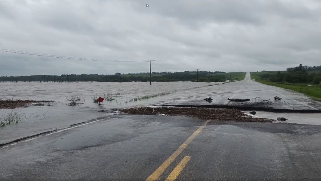
Transportation Arteries Under Water
The economic cost of this deluge extends far beyond ruined basements. The provincial highway network, which serves as the economic lifeblood for agricultural logistics and supply chains, suffered massive damage.
The Ministry of Highways reported at least 17 complete road closures and another 18 areas where water was actively flowing over driving lanes. Highway 49 between Norquay and Pelly was completely washed out, severing a key northern corridor. When a highway washes out, it is not merely an inconvenience for commuters; it stops the movement of grain, fuel, and groceries, driving up logistical costs across the province.
Repair crews are currently deployed across the east-central region, dumping gravel and using temporary materials to patch holes so that basic traffic can resume. These are temporary patches on a structural wound. The provincial government will eventually have to fund complete engineering reviews to determine if the base layers of these highways have been permanently compromised by internal erosion.
Small towns cannot afford to rebuild their infrastructure every time a stalled low-pressure system parks itself over the prairies. Provincial and federal funding models must shift from reactive disaster assistance to proactive infrastructure reinforcement. Until municipal water networks, highway culverts, and agricultural drainage policies are redesigned to handle rapid, high-volume water events, the communities of the Canadian prairies will remain completely exposed to the next great cloudburst.