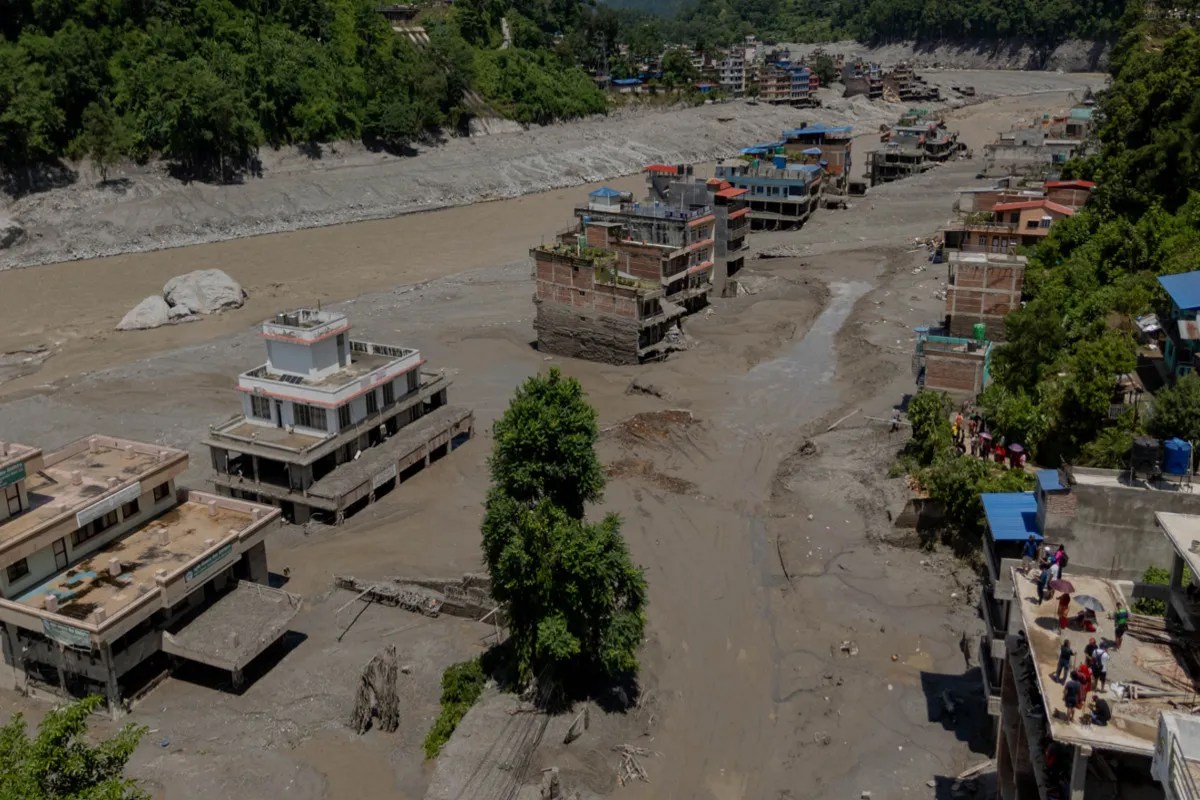
The physical mechanics of a glacial lake outburst flood are fundamentally deceptive. To an external observer, the immediate visual is one of water volume moving downward through a river valley. The economic and infrastructural reality, however, is an exercise in systemic shock propagation. When glacial melt breaches lateral moraine dams in the high Himalaya, the resulting hydrodynamic surge is not merely a localized weather disaster; it is a capital destruction event that tests the fiscal solvency, structural engineering capacity, and logistical resilience of a developing nation state. Recent estimates placing total economic recovery costs at five billion dollars expose a structural vulnerability in mountainous economies where infrastructure sits directly in the active alluvial paths of cryospheric anomalies.
Understanding this catastrophe requires deconstructing the event into three distinct phases: the hydrological trigger, the kinetic infrastructure failure, and the macro-fiscal recovery deficit. Each phase operates on different timelines and involves entirely separate vectors of vulnerability.
The Cryospheric Trigger and Hydrological Physics
Glacial lake outburst floods do not occur in isolation. They are the direct consequence of sustained thermal forcing acting upon high-altitude ice and debris-covered glaciers. As atmospheric temperatures rise across the Hindu Kush Himalaya region, accelerated ice melt accumulates in supraglacial ponds. These ponds coalesce into expansive glacial lakes held back by unstable barriers composed of loose rock, ice, and moraine debris.
The structural integrity of these natural dams is precariously low. Unlike engineered concrete structures, moraine dams lack internal reinforcement, controlled spillways, or grout curtains. When a critical threshold of water volume is reached—often triggered by seismic activity, ice avalanches plunging into the lake, or rapid snowmelt—the dam wall experiences catastrophic breaching.
The hydrograph of the resulting flood differs fundamentally from a standard monsoon-induced river swell. A standard flood rises over days, providing a window for evacuation and asset relocation. A glacial outburst produces a wall of water, mud, boulders, and ice that surges down narrow mountain valleys with hyper-concentrated sediment loads. The flow velocity can exceed ten meters per second, transforming the water into a dense, destructive debris flow that scours riverbeds, undercuts bridge abutments, and strips away topsoil. This kinetic energy scales exponentially with slope gradient and constriction points in the valley topography.
The Kinetic Infrastructure Failure Matrix
When the debris flow intersects human development, the destruction follows a predictable pattern dictated by asset localization. Mountain topography forces roads, hydropower plants, transmission lines, and human settlements into narrow river corridors. There is rarely an alternative alignment due to extreme terrain constraints.
Hydropower infrastructure represents the single largest capital vulnerability in this matrix. Run-of-the-river hydroelectric projects, which dominate the Himalayan energy landscape, rely on low-head diversion dams, desanding basins, and surface powerhouse structures located adjacent to riverbeds. When a glacial flood arrives, it overwhelms desanding capacity instantly. Tons of abrasive silt, gravel, and boulders scour turbine blades, choke penstocks, and completely bury electromechanical installations. The economic loss is not limited to the repair cost of the hardware; it extends to immediate regional blackouts, loss of export revenue, and compounding industrial downtime.
Transportation networks suffer a parallel collapse. Highways engineered into steep canyon walls rely on retaining structures, causeways, and bridges spanning the main river channel. A high-energy debris flow does not simply flood a road; it erodes the toe of the mountain slope, triggering secondary landslides that obliterate entire segments of concrete and asphalt. Rebuilding these transport links requires heavy geotechnical stabilization, including rock anchoring, soil nailing, and high-tensile mesh installation—operations that require specialized machinery and months of stable weather windows.
The spatial distribution of settlements compounds this vulnerability. Rural communities and expanding tourism hubs cluster on flat alluvial fans formed by tributary junctions. These fans appear stable over decades, but during an extreme flood event, they become deposition zones where the river abandons its channel and spreads laterally, burying homes, agricultural land, and localized water supply systems beneath meters of rocky debris.
The Macro-Fiscal Recovery Deficit
Quantifying recovery at five billion dollars is an exercise in aggregating direct asset destruction, indirect economic losses, and reconstruction cost inflation. Developing nations operating under constrained fiscal envelopes cannot absorb capital shocks of this magnitude without severe macroeconomic distortion.
The fiscal deficit is driven by three compounding economic pressures. First, public sector balance funds are immediately diverted from ongoing developmental expenditures—such as education, health, and routine infrastructure maintenance—toward emergency rescue, debris clearance, and temporary shelter provision. This creates a long-term drag on gross domestic product growth.
Second, the replacement cost of infrastructure built in high-risk zones exceeds original construction costs due to the necessity of climate-resilient redesign. Rebuilding a bridge to withstand standard seasonal floods is insufficient; engineers must now account for higher design discharge volumes, deeper scour depths, and reinforced pier protection. This shifts the capital expenditure curve upward, making every restored asset significantly more expensive per unit than its predecessor.
Third, the insurance and credit markets react sharply to systemic cryospheric risks. Sovereign debt yields may rise if international credit rating agencies view climate-induced infrastructure shocks as unmitigated structural liabilities. Furthermore, private property and commercial enterprises in high-risk river corridors face prohibitive premium increases or complete withdrawal of coverage, shifting the entirety of disaster risk retention back onto the state and individual property owners.
Strategic Capital Allocation and Risk Mitigation
Mitigating future catastrophic losses requires moving away from reactive reconstruction toward systematic risk reduction. Traditional post-disaster response models are financially unsustainable when the frequency of glacial lake outburst floods increases in tandem with global temperature anomalies.
Early warning systems represent the highest-return capital investment in mountain hazard management. Deploying automated sensor networks upstream—including pressure transducers, acoustic flow monitors, and satellite-linked radar telemetry—provides critical lead times ranging from minutes to hours. While minutes are insufficient for large-scale infrastructure relocation, they are adequate for automated shutdown of hydropower turbines, clearing of downstream bridges, and targeted evacuation of riverbanks.
Engineering interventions must also shift toward active risk reduction at the source. Controlled lowering of high-risk glacial lakes through siphoning, pumping, or artificial channel excavation reduces the hydrostatic pressure behind fragile moraine dams. While these engineering projects are technically complex and financially demanding, their cost is a fraction of the multi-billion-dollar reconstruction bills incurred downstream.
Zoning regulations must enforce strict setbacks from active glacial flood paths. In regions where economic activity is permanently bound to river corridors, building codes must mandate elevated foundation designs, sacrificial ground floors, and localized flood-retention walls. Without these structural adaptations, capital injection into mountain infrastructure will continue to function as a recurring subsidy for natural destruction.